Hiking
Yosemite National Park
SCOUT OUTINGS
Aviation
Space
Automobiles
Ships & Naval
Trains
Canoeing
Kayaking
Rafting
Sailing
Windsurfing
State
National
County
Regional
Indoor
Rock
Historic
Local
Rim of the Bay
Skyline
Bay Area Ridge
Tahoe Rim
Pacific Crest
Scuba
Stand Up Paddling
Surfing
Swimming
Yosemite National Park
Yosemite is one of the scenic wonders of the world and contains beautiful waterfalls, massive granite peaks, the oldest Sequoia (2,700 years old) and many other beautiful vistas. At Yosemite, there is hiking, horse riding, cycling, fishing and learning about the nature and history of Yosemite.
National Parks Website: http://www.nps.gov/yose/
Yosemite
National Park Information:
Our annual June weeklong outing took us to Yosemite National Park.
We decided at our planning meeting
to take hikes around Wawona to Mariposa Giant Sequoia Grove and
to tackle other hikes like the Upper Yosemite Falls, Bridal Veil Falls
and Mirror Lake. The venture team decided to try the Half Dome hike. We
split into two venture groups so that all of the adult leaders could try
the hike as well.
Campsites:
Group Sites: There are four group campgrounds in Yosemite: in Wawona, Tuolumne Meadows, Hodgdon Meadow and Bridalveil Creek. The valley group campground was destroyed in the January 1997 flood. Only Wawona and Hodgson are available most of the year, while Tuolumne Meadows and Bridalveil Creek do not open until after the snow melts in late June or early July. A maximum of 30 people are allowed in each group campsite, and check-in/check-out time is noon. There are about 6 bear boxes and all food or items that have fragrances must be stored in the boxes.
Wawona Group is located near the south entrance of Yosemite near Wawona near the terminus of Highway 41. It's located right at the south fork of the Merced River and provides lots of natural white noise.
Hodgson Group is located near the west end of Yosemite off of Highway 120.
Tuolumne Meadows is located along Tioga Road.
There are three sites in the valley floor in Lower Pines that can accommodate up to 12 campers, but are very difficult to book.
Family Sites: Campgrounds in Yosemite National Park are operated by the National Park Service. There are 13 campgrounds in the park. They are: (in Yosemite Valley) Lower Pines, North Pines, Upper Pines and Sunnyside Walk-in, (outside Yosemite Valley) Bridalveil Creek, Crane Flat, Hodgdon Meadow, Porcupine Flat, Tamarack Flat, Tuolumne Meadows, Wawona, White Wolf and Yosemite Creek.
Things
to do around Wawona:
Pioneer
Yosemite History Center
See horse drawn wagons, walk across a covered bridge, and visit historic buildings out of Yosemite's past. Take a 30-minute, self-guided tour through the Pioneer Yosemite History Center and learn about people and events of Yosemite. The Center is always open, and explanatory signs and brochures are available. Located adjacent to the Wawona General Store, across the Covered Bridge. Easy walking, except during extreme snow conditions.
Hiking:
Mariposa Grove of Giant Sequoias. The giant sequoias at Mariposa are among the world's oldest living things. The Grizzly Giant is believed to be 2,700 years old. One of trees still standing, although severely damaged, has a tunnel that you can walk through.
Swinging Bridge Loop. Start: Pioneer Yosemite History Center or Wawona Store. The paved road, Forest Drive, leads 2 miles upstream from the history center to the end of the paved road. Continue on the dirt road for a short distance until you get to the swinging bridge (which really does swing). Cross the bridge and bear left onto the dirt road, which soon becomes paved Chilnualna Falls Road. When you reach the Wawona Stable, walk into it towards the Covered Bridge, where you started this hike.
Swimming
There is a Swimming Tank, as they were originally called, at Wawona. This is the first swimming tank in the Sierra and one of the oldest in California! The campground is near the south fork of the Merced River so we'll see if there's a safe place to swim.
Fishing
We're
camping right next to the south fork of the Merced River so if you want
to get up before breakfast, try your hand at fishing. Please bring your
own fishing equipment if you plan to fish.
Things to do in Yosemite Valley
Hikes
A short 1/2 mile hike to the base of Bridal Veil Falls. Plan on being wet.
Mirror Lake. Another short hike to this small lake located near the base of Half Dome, which is reflected in it's water, hence it's name. It’s one mile to the lake and 3 miles to circle lake and feeding streams. The total hike was 5 miles.
Upper Yosemite Fall. Starts near Camp 4 (shuttle stop 7). This switch-backing trail takes you to the top of 2,425 foot (739 meter) high Yosemite Falls. The trail provides great views of Half Dome and eastern Yosemite Valley. If you continue about a half-mile beyond Columbia Rock, along a relatively easy section of the trail, you can get spectacular views of Upper Yosemite Fall. The look-out perch is located along a narrow cliff on the side of the walls.
Biking
Nearly a dozen miles of paved bikeways wind through the eastern end of Yosemite Valley. California law mandates bicyclists under 18 years of age wear a helmet. For your safety and to protect Yosemite National Park, please follow these rules.
-
Bikes are only allowed on paved bikeways and park roads (unless the road is closed to bike use).
-
All bikes are prohibited from pedestrian and hiking trails.
-
Bicyclists must obey all posted traffic signs and travel with the flow of traffic when on roadways used by automobiles.
Rental
bikes, baby jogging strollers, and bicycle baby trailers are available
at Yosemite Lodge (all seasons) and Curry Village (summer).
High Venture
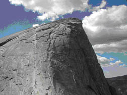 Half
Dome Hike
Half
Dome Hike
This is a strenuous hike and we reserved it for scouts 14 and older (and 13-year old scouts with special permission.) We did this hike in mid-week so that we'd have time to acclimate to the elevation. From Yosemite Valley, it encompasses a 4,800 foot gain in elevation over a 8.5 mile trail. A group of us started the hike from Glacier Point to Half Dome and then back up the Panorama Trail to Glacier Point. This was a challenge as we had to hike back up to Glacier Point after a long day of hiking and climbing.
Yosemite Valley Falls and Walls http://www.bsa-gyc.org/
What better way is there to experience Yosemite than to take a walk or
hike? Listed below are five day hikes originating in Yosemite Valley sponsored by the Greater
Yosemite Council. Use your common sense to
avoid accidents and injuries, and always remember to bring your own
drinking water on hikes. Remember to stop by a park visitor center
before your hike to get current trail and weather conditions, and to
prepare for thee unexpected; carry food and water, rain gear, and
emergency including matches and first aid supplies. It is wise to carry
a flashlight in case you return after dark.
five day hikes originating in Yosemite Valley sponsored by the Greater
Yosemite Council. Use your common sense to
avoid accidents and injuries, and always remember to bring your own
drinking water on hikes. Remember to stop by a park visitor center
before your hike to get current trail and weather conditions, and to
prepare for thee unexpected; carry food and water, rain gear, and
emergency including matches and first aid supplies. It is wise to carry
a flashlight in case you return after dark.
Detailed maps and hiking guides are available for purchase at park visitor centers and gift shops. Please remember that dogs and other pets, bicycles and mountain bikes, and motor vehicles are not allowed on park trails. Pets are allowed on paved paths on the floor of Yosemite Valley and must be kept on a leash at all times. Horses and mules have the right-of-way on trails. Hikers should step to the uphill side of the trail, if possible, and remain quiet while animals pass. Do not attempt to touch them.
|
Trail |
Starting Point |
Distance (Round Trip) |
Elevation Gain, Difficulty |
|
Mirror Lake |
Mirror Lake, Shuttle Stop 17 |
1 mile to Lake, 3 miles around Lake |
Little Gain, Easy |
|
Upper Yosemite Fall |
Sunnyside Camp, Shuttle Stop 8 |
7.2 miles round trip |
2700' Elevation Gain, Very Strenuous |
|
Nevada Fall, Mist Trail or John Muir Trail |
Happy Isles, Shuttle Stop 16 |
7 miles round trip |
1900' Elevation Gain, Strenuous |
|
Half Dome, Mist Trail or John Muir Trail |
Happy Isles, Shuttle Stop 16 |
17 miles round trip |
4800' Elevation Gain, Most Strenuous |
|
Glacier Point, Four Mile Trail |
Southside Drive |
4.8 miles one way |
3200' Elevation Gain, Very Strenuous |