Hiking
San Francisco Presidio Historic Hike
SCOUT OUTINGS
Aviation
Space
Automobiles
Ships & Naval
Trains
Canoeing
Kayaking
Rafting
Sailing
Windsurfing
State
National
County
Regional
Indoor
Rock
Historic
Local
Rim of the Bay
Skyline
Bay Area Ridge
Tahoe Rim
Pacific Crest
Scuba
Stand Up Paddling
Surfing
Swimming
Presidio Golden Gate Historic Trail Hike
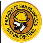
The Presidio Historic Trail, sponsored
by the San Francisco Bay Area Council, has a trail for Cub Packs and Boy
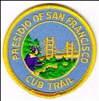
Scout Troops. The Cub Scout Trail is about 3.5-miles as it starts from
the Visitor Center, down to Fort
Point and then around to Battery Chamberlin.The Boys Scout Trail is
between 6.4 to 8.1 miles depending upon whether the troop hikes all
across the Golden Gate Bridge and back. Contact the SFBAC store to purchase the patch.
as it starts from
the Visitor Center, down to Fort
Point and then around to Battery Chamberlin.The Boys Scout Trail is
between 6.4 to 8.1 miles depending upon whether the troop hikes all
across the Golden Gate Bridge and back. Contact the SFBAC store to purchase the patch.
PDF Map of the Presidio:
http://www.nps.gov/goga/planyourvisit/upload/map-prsf-2008.pdf
 Cub
Scout Trail is a 3.5-mile
hike.
Cub
Scout Trail is a 3.5-mile
hike.
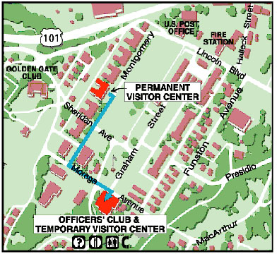
1. Start at the temporary Visitor Center. Information on points of interest and Presidio history is available as well as park brochures and maps. The temporary Visitor Center is located in the Presidio Officers Club, Building 50, Moraga Avenue (while the permanent center undergoes earthquake reinforcement). Go to Pershing Square located directly in front of the Visitor Center. A boulder by the sidewalk approximates the northwest corner of the original presidio, which formed a square about 300 feet (100 m) on each side. Two bronze cannons located here, originally were located at Castillo de San Joaquin, a fort built at the point overlooking the Golden Gate. They are among the oldest cannons in North America. Around the Main Post and Funston Avenue, you may see some archaeological investigatory digs. This investigation’s purpose is to locate and identify places in the area that may contain material of historical importance.
The Main Post area bounded by Montgomery, Moraga, Lincoln and Funston, was the heart of the old Spanish and Mexican Presidio and contains some of the oldest buildings.
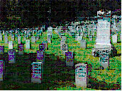
2. Go up to the top of the parade ground SW corner and turn on Sheridan Ave. Make a left onto Lincoln Blvd. You may want to spend a few minutes at the National Cemetery grounds to examine the graves, give thanks and talk about the sacrifices of past generations that enable us to enjoy our rights and freedom. Buried at the cemetery were a famous woman Civil War spy, and various heroes and generals from the Civil War, WWI and Spanish American Wars.
3. Proceed north on MacDowell Ave. past the stables. You will pass by a pet cemetery, the only one that was located on any military base. No, it is not for animals that died in the service of the armed forces, but just ordinary pets that belonged to families of the military. Cross Doyle Drive and follow Mason Street towards the bridge. You can visit the visitor center for the Gulf of the Farallones National Marine Sanctuary. Another option is to follow the trail along Crissy Field Road and then along Lincoln Blvd. to Battery East. At Battery East, you can view the earthen works and brick-lined magazines built to protect large Rodman guns and their ammunition. There are some great views from this area. The Gulf of the Farallones National Marine Sanctuary Visitor Center provides information on the sanctuary and features hands-on educational exhibits on local marine life.
If you’ve visited the Marine Sanctuary, proceed along Marine Drive to Fort Point. You can stop at the Warming Hut near the Torpedo Wharf. There are restrooms, food service and visitor information here. From Battery East, hike the trail to Marine Drive and to Fort Point.
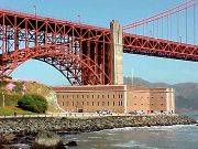 4. At Fort Point, you can see a movie on the fort and the history
of the Golden Gate
Bridge, if you have time.
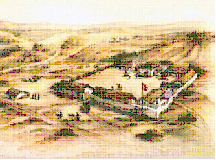
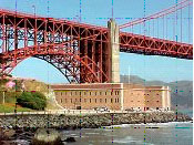
Fort Point, constructed between 1853
and 1861 by the U.S. Army Corps of Engineers, prevented the entrance of
hostile fleets into
San Francisco Bay.
4. At Fort Point, you can see a movie on the fort and the history
of the Golden Gate
Bridge, if you have time.
Fort Point, constructed between 1853
and 1861 by the U.S. Army Corps of Engineers, prevented the entrance of
hostile fleets into
San Francisco Bay.
From Fort Point, take the trail up towards the Golden Gate Visitor Center, which has a 300 feet elevation gain and you can hike up to the Golden Gate Bridge. The hike across the bridge is 1.7 miles so a round trip would be 3.4 miles. Or, you can hike halfway across to the center of the Golden Gate Bridge and then return to the trail and head back on the trail and add 1.7 miles to the hike. From just below the visitor center, the trail will bend to the right and become the Coastal Trail.
5. Follow the Coastal Trail for 1.5 miles to Baker Beach. You will be hiking along the bluff where several batteries were located to protect the area. The north section of Baker Beach is clothing optional so avoid it. Do not take the first beach entrance on the Coastal Trail (Never Ending Stairs.)
6. Take the second beach entrance and proceed to Battery Chamberlain. Battery Chamberlin holds the last 6-inch "disappearing gun" of its type on the West Coast. On the first full weekend of each month, between 11 a.m. and 3 p.m., you can take part in demonstrations of the gun and visit a small seacoast defense museum at the battery. This is a great spot for pick up. There is water, restrooms, parking lot and a pay phone here.
Total hiking distance is about 3.5 miles for Cubs.
Boy Scout Trail is 6.4 miles if camping at Rob Hill.
1. Start at the temporary
Visitor Center.
Information on points of interest and Presidio history is available as
well as park brochures and maps. The temporary Visitor
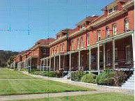
Center is located in the Presidio Officers' Club (photo on right), Building 50,
Moraga Avenue (while the center
undergoes earthqu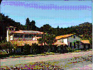 ake
reinforcement). Go to Pershing
Square located directly in
front of the Visitor Center. A boulder by the sidewalk approximates the northwest corner of the
original presidio, which formed a square about 300 feet (100 m) on each
side. Two bronze cannons located here, originally were located at
Castillo de San Joaquin,
a fort built at the point overlooking the Golden Gate. They are among
the oldest cannons in North America. This area was the Main Post and it
was the heart of the old Spanish and Mexican Presidio and contains some
of the oldest buildings.
ake
reinforcement). Go to Pershing
Square located directly in
front of the Visitor Center. A boulder by the sidewalk approximates the northwest corner of the
original presidio, which formed a square about 300 feet (100 m) on each
side. Two bronze cannons located here, originally were located at
Castillo de San Joaquin,
a fort built at the point overlooking the Golden Gate. They are among
the oldest cannons in North America. This area was the Main Post and it
was the heart of the old Spanish and Mexican Presidio and contains some
of the oldest buildings.
Around the Main Post and Funston Avenue, you may see some archaeological investigatory digs. This investigation’s purpose is to locate and identify places in the area that may contain material of historical importance.
2. Go up to the top of the parade ground
SW corner and turn on Sheridan
 Ave.
Make a left onto Lincoln Blvd. You may want to spend a few minutes at
the National
Cemetery grounds to
examine the graves, give thanks and talk about the sacrifices of past
generations that enable us to enjoy our rights and freedom. Buried at
the cemetery were a famous woman Civil War spy, and various heroes and
generals from the Civil War, WWI and Spanish American Wars.
Ave.
Make a left onto Lincoln Blvd. You may want to spend a few minutes at
the National
Cemetery grounds to
examine the graves, give thanks and talk about the sacrifices of past
generations that enable us to enjoy our rights and freedom. Buried at
the cemetery were a famous woman Civil War spy, and various heroes and
generals from the Civil War, WWI and Spanish American Wars.
3. Proceed north on MacDowell Ave. past the stables. You will also pass by a pet cemetery, the only one that was located on any military base. No, it is not for animals that died in the service of the armed forces, but just ordinary pets that belonged to families of the military. Cross Doyle Drive and follow Mason Street towards the bridge if you want to visit the visitor center for the Gulf of the Farallones National Marine Sanctuary. Another option is to follow the trail along Crissy Field Road and then along Lincoln Blvd. to Battery East. At Battery East, you can view the earthen works and brick-lined magazines built to protect large Rodman guns and their ammunition. There are some great views from this area. The Gulf of the Farallones National Marine Sanctuary Visitor Center provides information on the sanctuary and features hands-on educational exhibits on local marine life. Proceed along Marine Drive to Fort Point. You can stop at the Warming Hut, which has food service, restrooms, and restrooms.
4. At Fort Point, you can see a
movie on the fort and the history of the Golden Gate Bridge,
if you have time.
Fort Point, constructed between 1853
and 1861 by the U.S. Army Corps of Engineers, prevented the entrance of
hostile fleets into
San Francisco Bay.
From Fort Point, take the trail up towards the Golden Gate Visitor
Center, which has a 300 feet elevation gain and you can hike up to the
Golden Gate Bridge. The hike across the bridge is 1.7 miles so a
round trip would be 3.4 miles. Or, you can hike halfway across to the
center of the Golden Gate
Bridge and then return to the trail and head back on the trail and add 1.7
miles to the hike. From just below the visitor center, the trail will
bend to the right and become the Coastal Trail.

5. Follow the Coastal Trail for 1.5 miles to Baker Beach. You will be hiking along the bluff where several batteries were located to protect the area. The north section of Baker Beach is clothing optional so avoid it. Do not take the first beach entrance on the Coastal Trail (Never Ending Stairs.)
6. Take the second beach entrance and proceed to Battery Chamberlin. Battery Chamberlin built in 1904, holds the last 6-inch "disappearing gun" of its type on the West Coast. On the first full weekend of each month, between 11 a.m. and 3 p.m., you can take part in demonstrations of the gun and visit a small seacoast defense museum at the battery. This area has restroom facilities and a pay phone.
7. Troops not spending the night can be picked up at Battery Chamberlin. For troops with reservations for spending the night at Rob Hill campsite, hike back up the Coastal Trail and veer right on Kobbe Road. Turn right on to Washington Blvd. and turn left on Central Magazine Road. Make a right on the gated trail to the campground. Reservations are required.
Camping
 Overnight
Camping is not a requirement for this badge, but is available at Rob
Hill Campground. Season: April 1 - October 31 Reservations are available on a rolling basis several months in advance.
Overnight
Camping is not a requirement for this badge, but is available at Rob
Hill Campground. Season: April 1 - October 31 Reservations are available on a rolling basis several months in advance.
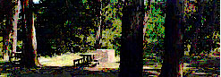
Description: Rob Hill is located in a grove of Eucalyptus trees in
the Presidio of San Francisco.
Capacity: Rob Hill has two group sites. Each site can accomodate up
to thirty people.
Amenities: Portable toilets, picnic tables, BBQ grills, and a
central campfire ring. Water is available.
Cost: $125 per site, per night. For reservations, get application at: http://www.presidio.gov/places/Pages/rob-hill-campground.aspx
 The
Presidio of San Francisco
The
Presidio of San Francisco
Introduction
For thousands of years, the Ohlones lived in the area that is now the Presidio. In 1776, Juan Batista de Anza led an expedition from Sonora, Mexico to San Francisco to claim this territory for Spain.
The Presidio served as a military post under the flags of Spain (1776-1822), Mexico (1822-48), and the United States (1848-1994). As a U.S. Army post, the Presidio protected commerce and trade, and played a logistical role in every major U.S. military conflict over the last 150 years.
History of the Presidio
In 1776 the Spanish formally took possession of the area presently know as the Golden Gate. Under the command of Capt. Juan Bautista de Anza, the Spanish moved quickly to fortify the area, and by the winter of 1776, a military camp located in a sheltered vale inland from the headlands was completed. The new outpost was named the Presidio of San Francisco (in honor of St. Francis of Assisi). Once completed, Spain sent a garrison of troops to protect the outpost and the surrounding area. The duties of the garrison included guarding the nearby Mission, which was later known as Mission Dolores; and "controlling" the Indians of the area. Its commandant also received instructions to regulate the coming and going of foreign ships, whether they were British, French, Russian, or American. [1. Thompson, Erwin N. Defenders of the Gate: A History from 1846 to 1995. California: National Park Service, 1997.]
 The Presidio marked the northernmost advance of
Spain's empire in North America at a
time of intense international rivalry among western powers in the North
Pacific. The Presidio was more of a village than a fortification,
although the buildings were defensively arranged. With only two cannons
supplied to the garrison, the initial defenses of the Bay offered
nothing more than a facade of strength. One cannon exploded in a
training exercise, and the remaining cannon lacked adequate gunpowder to
defend against a sustained attack. When Captain George Vancouver, of the
British Frigate H.M.S. Discovery, entered the gate in 1792, he
fired his cannon to salute the Spanish flag, but there was no response
from the Spanish garrison at the Presidio. This breach of etiquette
caused confusion among the crew of the Discovery, until a soldier
from the Presidio rowed out to the ship and requested gun powder to
return the salute. When Spanish officials heard of this show of
weakness, artillery and new fortifications were quickly ordered for the
area. Several bronze guns were sent to the Presidio, six of which remain
at the Presidio today.
[2. Barker,
Blind, and Bernaal. El Presidio de
San Francisco
Archaeological Site Tour.
California: National Park Service, 2001.]
The Presidio marked the northernmost advance of
Spain's empire in North America at a
time of intense international rivalry among western powers in the North
Pacific. The Presidio was more of a village than a fortification,
although the buildings were defensively arranged. With only two cannons
supplied to the garrison, the initial defenses of the Bay offered
nothing more than a facade of strength. One cannon exploded in a
training exercise, and the remaining cannon lacked adequate gunpowder to
defend against a sustained attack. When Captain George Vancouver, of the
British Frigate H.M.S. Discovery, entered the gate in 1792, he
fired his cannon to salute the Spanish flag, but there was no response
from the Spanish garrison at the Presidio. This breach of etiquette
caused confusion among the crew of the Discovery, until a soldier
from the Presidio rowed out to the ship and requested gun powder to
return the salute. When Spanish officials heard of this show of
weakness, artillery and new fortifications were quickly ordered for the
area. Several bronze guns were sent to the Presidio, six of which remain
at the Presidio today.
[2. Barker,
Blind, and Bernaal. El Presidio de
San Francisco
Archaeological Site Tour.
California: National Park Service, 2001.]
In March of 1847, U.S. troops occupied the Presidio of San Francisco, and the government of the United States acquired all of the public lands formerly claimed by Mexico. In addition to the Presidio, the U.S. took possession of several islands including Angel and Alcatraz. During this period, most of the current Presidio was acquired. In 1848, the discovery of gold in California gave a new importance to the harbor of San Francisco. Increased trade prompted the military to begin the construction of coastal defenses for the San Francisco Bay. [3. Freeman, Haller, Hansen, Martini, and Weitze. Seacoast Fortifications Preservation Manual. Golden Gate National Recreation Area, July 1999.
In the fortification strategy commonly referred to as the Plan of 1850, cannons mounted at the north and south shores of the Golden Gate would use crossfire on enemy ships entering the bay. In addition, the Plan sought to establish an ancillary fortification inside the bay on Alcatraz Island. With all three of these fortifications in place, hostile ships attempting to penetrate the bay would become trapped in a deadly triangle of fire from all three forts. Construction of these coastal defenses began in 1853. [3. Freeman, Haller, Hansen, Martini, and Weitze. Seacoast Fortifications Preservation Manual. Golden Gate National Recreation Area, July 1999. http://www.nps.gov/goga/history/seaforts/chapter2/chapter2.htm#civilwar]
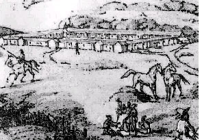
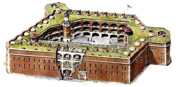
Designed to be the equal of any fort in the country, the brick-and-mortar Fort Point, located at the south shore of the Golden Gate, boasted three casemated tiers and a top barbette tier. Construction was completed in 1861 and the fort and its outworks had emplacements for 141 guns of various types, but only 55 cannons and 11 mortars were mounted at that time. [3. Freeman, Haller, Hansen, Martini, and Weitze. Seacoast Fortifications Preservation Manual. Golden Gate National Recreation Area, July 1999.
On October 1, 1994, the Presidio became part of the Golden Gate National Recreation Area. Since 1998, the Presidio has been jointly managed by the National Park Service and the Presidio Trust. The Presidio Trust is a special public-private governmental agency tasked with managing most of the buildings of the Presidio and making the park financially self-sufficient by 2013.
Today, visitors can enjoy the history and beauty of the Presidio. Within its 1,480 acres are more than 500 historic buildings, a collection of coastal defense fortifications, a national cemetery, an historic airfield, a saltwater marsh, forests, beaches, native plant habitats, coastal bluffs, miles of hiking and biking, and some of the most spectacular vistas in the world.
Visitor Center
Information on points of interest and Presidio history is available at the Visitor Center, temporarily located in the Presidio Officers' Club, Building 50, Moraga Avenue (while the permanent structure undergoes earthquake reinforcement). Several videos can be viewed in the theater and a bookstore offers topical books and other media.
Pershing Square
Pershing Square, named after the famous
WWI general, General “Blackjack” Pershing, was a base commander at the
Presidio. Just east lies the site of the orig inal
Spanish presidio, built in 1776 on this windswept slope. A boulder by
the sidewalk approximates the northwest corner of the original presidio,
which formed a square about 300 feet (100 m) on each side. Two bronze
cannons forged in the 1600s are located here were and were originally
mounted at Castillo de San
Joaquin, a fort built at the point overlooking the Golden Gate. They are
among the oldest cannons in North America.
inal
Spanish presidio, built in 1776 on this windswept slope. A boulder by
the sidewalk approximates the northwest corner of the original presidio,
which formed a square about 300 feet (100 m) on each side. Two bronze
cannons forged in the 1600s are located here were and were originally
mounted at Castillo de San
Joaquin, a fort built at the point overlooking the Golden Gate. They are
among the oldest cannons in North America.
Funston Avenue Archaeology
Along Funston Avenue, there has been some investigation into the archaeology of the area. You can see some excavations in this area that is part of the investigation. After excavation, a great deal of work goes into cleaning, inventorying, analyzing, and interpreting the materials we recovered. The dirt from excavations is taken to our field lab. Materials are screened using water to wash away the dirt and clean any artifacts. Lab volunteers then sort the artifacts into categories (e.g. ceramics, glass, bone, and plant materials).
Fort Winfield Scott
Situated near the gun batteries of the coastal bluffs, Fort Scott was established in 1912 to serve as headquarters for the Coastal Artillery Corps of the San Francisco Bay area. Spanish Revival style buildings, the first of this style to be built on the Presidio, characterize the post, and the U-shaped parade ground breaks from traditional quadrangular design. With the advent of missiles and long-range bombers after World War II, Fort Scott lost its strategic position and became part of the Presidio in 1956.
San Francisco National Cemetery
In 1884, San Francisco National Cemetery became the first West Coast cemetery to be part of the national cemetery system. Soldiers were buried here at the post cemetery as early as 1849. Through time, the cemetery expanded from 9 acres to its present 27 acres and contains over 30,000 graves, including those of 35 congressional Medal of Honor recipients.
Main
Post
The Main Post lies at the heart of the Presidio and marks the site of the Spanish presidio (garrison) established in 1776. This historic site served as a Spanish military base for 45 years, was under Mexican control for 25 years and, starting in 1846, was an important U.S. Army post for over 140 years. The Presidio's oldest existing buildings, dating back to 1861 and the Civil War, are found on the Main Post.
Crissy Field
 During
World War I, barracks for 6,000 soldiers covered the area prior to
construction of the airfield in 1919.
Crissy Field played an important role in
the pioneering years of military and commercial aviation as one of the
earliest army air bases on the West Coast. Flying records were set here,
aviators who became famous for their contributions were stationed here,
and history-making long-distance flights started and ended here.
During
World War I, barracks for 6,000 soldiers covered the area prior to
construction of the airfield in 1919.
Crissy Field played an important role in
the pioneering years of military and commercial aviation as one of the
earliest army air bases on the West Coast. Flying records were set here,
aviators who became famous for their contributions were stationed here,
and history-making long-distance flights started and ended here.
Letterman Complex

Letterman General Hospital, the U.S. Army's oldest named general hospital, was established in 1898 to care for sick and wounded soldiers returning from the Philippine Islands during the Spanish American War. Letterman became the largest Army hospital in the country during World War II, treating over 76,000 patients in 1945. Until its closure in 1992, Letterman Hospital provided medical care for soldiers during every major U.S. conflict of the 20th Century.
Gulf of the Farallones National Marine Sanctuary
The Gulf of the Farallones National Marine Sanctuary Visitor Center provides information on the sanctuary and features hands-on educational exhibits on local marine life. The visitor center is housed in the historic Coast Guard Station at the west end of Crissy Field.
 Battery
East
Battery
East
Built in the 1870s, Battery East was constructed to withstand the new heavy ordinance that made multi-tiered, masonry forts (like Fort Point) obsolete in the Civil War. You can view the earthen works and brick-lined magazines built to protect large Rodman guns and their ammunition. There are some great views from this area. There is also a parking lot nearby.
Fort Point National Historic Site
 Fort
Point constructed by the U.S. Army Corps of Engineers between 1853 and
1861 to
prevent
entrance of a hostile fleet into San Francisco Bay.
Fort
Point constructed by the U.S. Army Corps of Engineers between 1853 and
1861 to
prevent
entrance of a hostile fleet into San Francisco Bay.
The fort had a capacity of 126 massive cannons. The brick construction fort, occupied throughout the Civil War, was made obsolete by the advent of faster, more powerful rifled cannon. In 1886, the troops were withdrawn and the last cannon were removed about 1900. The fort became a storage and training facility for many years.
Golden Gate Bridge
The Golden Gate
Bridge is one of the most famous and beautiful bridges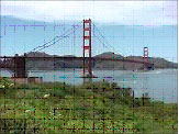 in the world because of its spectacular location, graceful lines, Art
Deco detailing, and emblematic color. With towers extending 700 feet into the sky and over
100 feet beneath the bay, the bridge is also an engineering marvel.
in the world because of its spectacular location, graceful lines, Art
Deco detailing, and emblematic color. With towers extending 700 feet into the sky and over
100 feet beneath the bay, the bridge is also an engineering marvel.
You may walk or bike the entire length of the 1.7 mile-long bridge.
Pedestrian Access
April - October (Daylight Savings Time):Pedestrians are allowed only on the EAST sidewalk, during daylight hours from 5 am to 9 pm. Gates close automatically at 9 pm and reopen at 5 am.
November - May (Pacific Standard Time): Pedestrians are allowed only on the EAST sidewalk, 6 am to 6 pm. Gates close automatically at 6 pm and reopen at 6 am.
Coastal Bluff
The Coastal Trail goes from the Golden Gate Bridge and along the top of the bluffs on western part of the Presidio. It passes by several defense batteries built in the 1890’s. Here, you will have a chance to view some of the natural plants including some rare and endangered species. You can hike the Coastal Trail to Ocean Beach. From the Golden Gate Bridge, this is about an 11-mile route.
Baker Beach
Mile-long Baker Beach lies at the foot of rugged serpentine cliffs west of the Golden Gate. Large waves, undertow and rip currents make the beach unsafe for swimming, but it provides panoramic views of the Golden Gate Bridge, Marin Headlands and Lands End. You can fish or check out the shorelife along the beach and rocky shoreline. Warning! The north end of Baker Beach is Clothing optional. Take the second stairs to avoid this area. Restrooms and picnic tables are nearby.
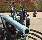 Battery
Chamberlin
Battery
Chamberlin
Battery Chamberlin, built near Baker Beach in 1904, was constructed as part of a modernization effort to accommodate the lighter, stronger, more powerful coastal defense weapons developed in the 1880s.
Today Battery Chamberlin holds the last 6-inch "disappearing gun" of its type on the West Coast. On the first full weekend of each month, between 11 a.m. and 3 p.m., you can take part in demonstrations of the gun and visit a small seacoast defense museum at the battery.
Rob Hill Campground
Rob
Hill Campground has two campsites that accommodate a maximum of 30
campers. The De Anza Trail goes past near the campsite. Also near the
campsite was the site of Nike Missiles that were located on the base in
the 1960’s.
Bay Area Ridge Trail
A 2.5-mile section of the Bay Area Ridge Trail is also located within the Presidio. The trailhead starts near the clubhouse at the Presidio Golf Course off West Pacific Avenue and Arguello Blvd.
Mountain Lake
Mountain
Lake is located near the
southern edge of the Presidio near Highway 1 and Funston Blvd. The lake
was the site that the De Anza expedition camped.
Modified January 19, 2016