Hiking
Mission Peak
Rim of the Bay
SCOUT OUTINGS
Aviation
Space
Automobiles
Ships & Naval
Trains
Canoeing
Kayaking
Rafting
Sailing
Windsurfing
State
National
County
Regional
Indoor
Rock
Historic
Local
Rim of the Bay
Skyline
Bay Area Ridge
Tahoe Rim
Pacific Crest
Scuba
Stand Up Paddling
Surfing
Swimming
![]() Indicates past or planned troop outing
Indicates past or planned troop outing
Hiking: Mission Peak Rim of the Bay Hike
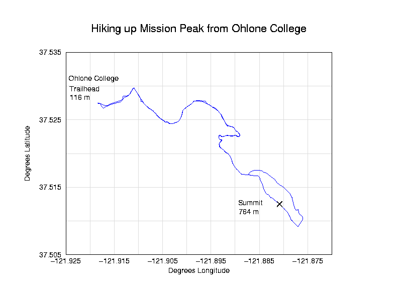
OUTING: This segment of the Rim of the Bay is the closest to us. It's located in Milpitas near the Sunol Wilderness. The hike can be started from either Ohlone College (Peak Trail) or from the end of Stanford Avenue (Hidden Valley Trail.)
Peak Trail: From parking lot at Ohlone College, hike to site of the campus swimming pool at back of campus (Lot H). Looking toward the hills, you will see a hiker's stile. Climb over the stile and take PEAK TRAIL to Mission Peak.
Hidden Valley Trail: From the staging area at the east end of Stanford Ave., take the Hidden Valley Trail. From the map, this appears to have many switchbacks, and although only .2 miles longer than Peak Trail, seems less inviting.
TRAVEL DIRECTIONS: Highway 880 to Durham Road exit. East on Durham Road to Mission Blvd. Turn left on Mission Blvd. to either entrance of Ohlone College (parking 50 cents per car when school is in session). Buy parking permit at lot D or H, or turn onto Stanford Ave. and drive east to the staging area where cars can park free of charge.
CLOTHING AND EQUIPMENT:
Clothing will depend on the season. During the summer months, it will be HOT!! During the other times, the weather may change so dress in layers. The summit area is unprotected and is often windy (therefore it may feel a lot colder!) Bring plenty of water since there are no water sources on the trail
THE HIKE
Hike Length: 6.9 miles round trip (Peak Trail)
Elevation: 2,517'
Elevation Gain: 1,997'
This more gradual ascent begins behind the swimming pool at the college's southeast corner. The trail often narrows to a single track. Hikers on this trail see more trees and wildflowers than Stanford Avenue starters, as they wind behind Mission Peak above Mill Creek Road. You'll also meander through cow pastures and during the wet season, this area may be very muddy due to the 'cow traffic' as they travel to the watering hole.
As you go up the trail, the last 1/2 mile become more steep without any switchbacks. If you haven't hiked much, you'll feel it in your quads! Mission Peak summit offers the best view of the South Bay and there's a post with many holes that you peek through to sight different landmarks.