Hiking
Folsom Lake Trails
SCOUT OUTINGS
Aviation
Space
Automobiles
Ships & Naval
Trains
Canoeing
Kayaking
Rafting
Sailing
Windsurfing
State
National
County
Regional
Indoor
Rock
Historic
Local
Rim of the Bay
Skyline
Bay Area Ridge
Tahoe Rim
Pacific Crest
Scuba
Stand Up Paddling
Surfing
Swimming
Folsom Lake Treks Top
To visit the website of the original content, visit: http://www.gec-bsa.org/program/training/adulttraining/highadventure/favoriteplaces/folsom
 Introduction
to Folsom Lake Treks
Introduction
to Folsom Lake Treks
The Folsom Lake Treks wander the perimeter of Folsom Lake, California, forming an excellent set of linked hikes. Each segment makes an ideal day hike about 10 miles long, with easily accessible trailheads at both ends. Since each segment is 10 miles, they are outstanding for boy scouts working on the Hiking merit badge. Several may also be turned into overnight trips by using the campgrounds and minimum impact campsites around the lake. Each segment may be hiked in either direction. For consistency, this guide proceeds counterclockwise around the lake. However, some segments are best hiked in the opposite direction.
The USGS 7.5 minute quadrangles that cover the area are Auburn, Pilot Hill, Rocklin, Folsom, and Clarksville. Maps and TOPO! software trail diagrams are also available on the Internet. A simple, but sufficient trail map is also available at the Folsom Lake State Recreation Area Headquarters on Folsom Dam Road. The park headquarters is usually open only on weekdays from 9 a.m. to 5 p.m. Consult Loomis and El Dorado area road maps or the Internet for driving directions to the trailheads.
The only facilities on the trail are at Granite Bay, Beal's Point, Brown's Ravine, and Peninsula Campground. Take along as much water as you can carry. Lake water can be purified or filtered, but has a decided saline taste. These treks can be hot and sweaty affairs in the summer and early fall. Be sure that you have made adequate arrangements for food, water, and First Aid. Poison Oak growth is heaviest in spring and summer, but present all year round. Awareness is key as some trails are literally overgrown with it. Also, insure that hikers are familiar with proper trail sanitation. Dig catholes 200 feet from the water and the trail.
The segments on the north side of the lake follow the Pioneer Express trail. On the south side, the Brown's Ravine trail. Both of these are popular with equestrians. The peninsula segments follow the Darrington trail, which is very, very popular with mountain bikers. Watch for riders of both kinds at all times. When you encounter riders on a single-track trail, step off to the side and stand quietly until they pass. Loud noises and sudden movements can spook horses.
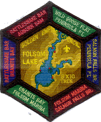
A very nice set of patches for this trail are available from the Golden Empire Council High Adventure Team. The set consists of a hexagonal main patch with a "rocker" patch for each segment. See above for a picture. The main patch is $3.50 and the rockers are $1.25 each. Contact John W. Jones, 530-758-9867, to order.
Auburn Dam to Rattlesnake Bar
Trailheads
· Auburn Dam Overlook. Take Highway 80 to Auburn. Take the Maple Street exit. Maple Street climbs the hill and joins Auburn-Folsom Road. Turn left at Pacific Avenue and proceed to the overlook parking area. Because of erosion and old dam construction damage, some people have reported confusion when starting the trek from this site.
· Maidu Drive alternate. Another trailhead can be found at edge of the town of Auburn, off of Auburn-Folsom Road, on Maidu Drive. As Maidu Drive crests the top of the hill, the road enters the Auburn State Recreation Area. You are greeted with the American River Canyon and a view of the Auburn Dam site. Just over the top, the trailhead can be found on the right side of the road. The access gate is blocked from vehicle traffic with a large rock. Parking here is limited.
· Rattlesnake Bar. From Auburn, take Auburn-Folsom road south. Turn left onto Rattlesnake Bar Road at Scott's Corner where it forms a 'Y' with Shirtland Tract Road. From Granite Bay (Douglas Blvd.), take Auburn-Folsom Road north. Turn right on Newcastle Road. Turn right again when Newcastle Road joins with Rattlesnake Bar Road. Proceed down the hill to the parking area at the boat launch ramp.
Because of the steep elevation change, this segment is best hiked downhill from Auburn to Rattlesnake Bar. If you have difficulty finding the trail start, look for it at the equestrian staging area. If you start from Maidu Drive, follow the well-worn path, marked with trail signs and occasional florescent plastic tape, downhill to meet the main trail about halfway to the canyon floor. At the bottom of the canyon the trail becomes very well defined, and remains so all the way to Rattlesnake Bar. This is the Pioneer Express trail that, according to the signs, runs all the way to Discovery Park in Sacramento.
Much of this segment runs next to an old concrete flume and through old orchards. There are several locations along the trail for lunch and time out for a swim (be sure to follow Safe Swim Defense). At Mormon Ravine you cross over South Canal on a nice wooden bridge and climb to pass a unique low-head power generation station. Stop and check this out. The trail then crosses below the station parking lot, passes an old pond, and then Avery's Pond minimum impact campsite. The trail exits at Rattlesnake Bar on the entrance road, west of the main parking areas.
Rattlesnake Bar to Granite Bay
Trailheads
· Rattlesnake Bar. From Auburn, take Auburn-Folsom road south. Turn left onto Rattlesnake Bar Road at Scott's Corner where it forms a 'Y' with Shirtland Tract Road. From Granite Bay (Douglas Blvd.), take Auburn-Folsom Road north. Turn right on Newcastle Road. Turn right again when Newcastle Road joins with Rattlesnake Bar Road. Proceed down the hill to the parking area at the boat launch ramp. From the parking lot a short spur trail heads uphill to join the Pioneer Express trail. You can also find the trail by starting at the equestrian assembly area.
· Granite Bay. From either Highway 80 or Auburn-Folsom road, proceed east on Douglas Blvd. until it dead-ends at the Granite Bay complex. This is a large area with several parking lots, so be sure to arrange a definite meeting point within. There is a parking lot just inside the entrance kiosk and another at the equestrian assembly area.
This segment is well defined all the way to Granite Bay. However, as you approach the populated areas around Granite Bay, the main trail is intersected by many access trails. Be sure to keep to the main trail running parallel with the lake shore. Watch for poles with a footprint embossed on them.
The trail rounds Horseshoe Bar, snakes into Beeks' Bight, and cuts over the ridge, bypassing Doton's Bar. The final couple miles closely approach many backyard fences until just outside the Granite Bay park. The trail enters the improved park facilities in the horse trailer area. It's a short walk to the main parking area and the commercial beach services.
Granite Bay to Brown’s Ravine
Trailheads
· Granite Bay. From either Highway 80 or Auburn-Folsom road, proceed east on Douglas Blvd. until it dead-ends at the Granite Bay complex. This is a large area with several parking lots. Use the one just inside the just inside the entrance kiosk from which it is easy to find the main trail.
· Brown's Ravine. From Folsom, take Natoma street or Blue Ravine Road until they intersect to form Green Valley Road. Continue on Green Valley for about 4 miles. The Brown's Ravine and Folsom Marina entrance will be on your left. From Highway 50 take the El Dorado Hills Blvd. exit. Follow El Dorado hills Blvd. east until it intersects with Francisco Drive. Turn left on Francisco Drive and continue to the Green Valley Road intersection. Turn left on Green Valley Road and head downhill. The entrance will be on your right, near the bottom of the hill. Just past the entrance kiosk on the right is the equestrian assembly area. Park here, or to save $3.00, park on Green Valley Road at the turnoff.
From the Granite Bay parking lot, hike towards the lake until you hit the main trail. At this point, it is fire road width, although closed to vehicles. Follow the trail below many private residences, then along the back sides of Dikes 4, 5, & 6 and into the Beal's Point campground. You can also hike along the tops of the dikes to avoid descending into the ravines and climbing back out. Reservations are usually required to camp at Beal's Point.
The trail continues down the Folsom segment of the American River bicycle trail to the entrance of Folsom Dam Road. Foot traffic is not allowed across the top of the dam, so to complete this segment there are at least three alternatives.
1. You can arrange to have vehicles meet your group at Folsom Dam Road and shuttle them across the dam to the overlook on the other side.
2. With prior arrangements, you may obtain a tour through the inside of the dam, exiting on the far side, to climb the Folsom Prison property to the road. Carefully ascend the rocky hill along the edge of the dam. DO NOT use the convenient stairway to nowhere that leads out onto the dam face. This option requires coordination with the Folsom Lake State Park Service and the Folsom Prison. You must be sure to be at the dam site on time. The Folsom Lake State Park Service office phone number is 916-989-7275.
3. Continue on the bike trail down to the Negro Bar campground to complete ten miles. At this point, you are very close to the Nimbus Fish Hatchery on Hazel Avenue. The hatchery visitor center is open most days. You can also arrange a tour if you call in advance. The hatchery office phone number is 916-355-0666.
If you opt to cross the dam and continue on to Brown's Ravine, resume walking at the overlook parking area. Hike carefully along the shoulder of Folsom Dam Road until the trail diverges off along the top of Dike 7. Continue across Dike 8 and then through the Folsom Point (Dike 8) Picnic Area. Crossing the Mormon Island Dam and rounding the point brings you to Brown's Ravine where you will see the boats at Folsom Marina.
Brown’s Ravine to Salmon Falls Bridge
Trailheads
· Brown's Ravine. From Folsom, take Natoma Street or Blue Ravine Road until they intersect to form Green Valley Road. Continue on Green Valley for about 4 miles. The Brown's Ravine and Folsom Marina entrance will be on your left. From Highway 50 take the El Dorado Hills Blvd. exit. Follow El Dorado hills Blvd. east until it intersects with Francisco Drive. Turn left on Francisco Drive and continue to the Green Valley Road intersection. Turn left on Green Valley Road and head downhill. The entrance will be on your right, near the bottom of the hill. Just past the entrance kiosk on the right is the equestrian assembly area. Park here, or to save $3.00, park on Green Valley Road at the turnoff.
· Salmon Falls bridge. Salmon Falls Road diverts from the left side of Green Valley Road about one half mile north of the Francisco Drive and Green Valley Road intersection. Follow Salmon Falls Road for about six miles until you reach the bridge. Park in the lot on the left side of the road, just before the bridge.
· Falcon Point alternate. About three miles before you get to the Salmon Falls bridge is a large pullout on the left with a sign reading "Falcon Point". This is the Monte Vista trailhead. Note that this is only about 4 miles by road from Brown's Ravine, making for an easy shuttle if you leave one car at the end of your hike and park the rest at the beginning.
This segment furnishes a very enjoyable hike. The trail is well groomed and gentle, generally contouring 100-200 above the lake. There are no long climbs or descents, just a few short hills. The trail is easy to follow with lots of trail markers and distance posts every half mile. Much of the trail is shaded in oak and pine forests, providing welcome relief on a warm day. Along the way there are many nice views of the south finger of the lake and the rugged, undeveloped country on the other side. This is the same country you will be hiking through on the next segment.
The full segment from Brown's Ravine all the way to the bridge is about 16 miles. A 10 mile alternative runs from Brown's Ravine to the Monte Vista trailhead at Falcon Point. This alternative is best hiked in reverse to be sure you don't miss the Monte Vista turnoff and to end at Brown's Ravine where facilities and water are available while waiting for car shuttles or rides. However, for consistency, the description below starts at Brown's Ravine.
Departing from the equestrian assembly area, follow the trail as it skirts the edge of the marina and then rounds the end of Brown's Ravine in fir trees a little above the lake. Next, the trail wanders below the homes in Lake Hills Estates. Passing through some of these developed residence areas, many use trails cross the main trail. Keep in mind that the main trail tends to contour along the lake shore. Also, look for the State Recreation Area trail markers with distances every half mile.
This route is only about 3 miles as the crow flies, but 10 by the trail that follows every contour of the lake. Nowhere is this more apparent than at New York Creek Cove. When you reach the mouth of the cove, you can see where you are going about 1/4 mile across the water. However, you have to walk 4 miles to get there. Crossing New York Creek at the head of the cove takes some doing. The ford is 20 feet across and calf to knee deep if you wade it. If the creek is not running high, you may be able to hop across on rocks. If neither of these appeal to you, walk another 1/4 mile upstream, cross on the highway bridge, and pick up the trail on the other side.
Shortly before you get back to the main lake, the Monte Vista trail branches right and heads uphill to Falcon Crest. Take this path to yield a 10 mile hike. Otherwise, continue to follow the lakeshore. Pass the Old Salmon Falls equestrian assembly area, which is 12 miles from Brown's Ravine. If the lake is below half volume, look for the old Salmon Falls bridge that crossed the American River before it was submerged.
The final 3 miles of this trail were built by local mountain bike clubs and are open to bicycles. You'll surely encounter some on any weekend. There can be no mistaking the endpoint of this trek. As the canyon narrows, the river is suddenly spanned by a large bridge. You've made it!
For boy scouts working on the Hiking merit badge, combining this segment with the portion of the previous segment that starts at the Folsom Dam overlook yields a 20 mile hike. Starting from the bridge gives you several places in the latter part of the hike to get fresh water and meet a car to pick up any hikers too tired to continue.
Salmon Falls Bridge to Peninsula Campground
Trailheads
· Salmon Falls bridge. Salmon Falls Road diverts from the left side of Green Valley Road about one half mile north of the Francisco Drive and Green Valley Road intersection. Follow Salmon Falls Road for about six miles until you reach the bridge. Park in either of the lots just across (north of) the bridge. The trail starts from the lot on the left side of the road.
· Peninsula Campground. Take Highway 49 to Pilot Hill. You can access Highway 49 by continuing up Salmon Falls Road, or from Auburn or Placerville. Take Rattlesnake Bar Road and follow the signs to the campground, a long and narrow nine miles from Pilot Hill. Once past the entrance kiosk, turn right and follow the signs to park at the campground boat ramp.
The trail departs Salmon Falls Bridge and traverses a steep, scrub covered hillside. The first several miles follow the lakeshore, diving in and out of many deep ravines and tunneling through the vegetation. After Hancock Creek, the trail skirts the steep footing of Flagstaff Hill.
On the far side of Deep Ravine, the trail intersects and intermittently follows a park service road that climbs the ridge west of the ravine. At the top, it meets the Ridge Trail and the mountain bike route turns right. The hiking trek continues straight, towards the Peninsula Campground, passing a service access road.
As you near the campground, you can take the shortest route for a hike of about 8 miles, or you can join the nature trail loop that heads south and adds another 2 miles. Follow the trail all the way out to the end of the point and enjoy sweeping views of the lake. Then return on the nature trail, which enters the campground at the road loop near the amphitheater. There are extensive camping facilities available here, but no commercial services. Although this large campground is little used, reservation are still advised.
The development of this segment is due in no small part to the actions of local Boy Scout troops and mountain bike clubs. Your group can help support these trails, too. Coordination for trail work and service projects should be done through the Folsom Lake Park Service.
Return To Top
Peninsula Campground to Goose Flat
Trailheads
· Peninsula Campground. Take Highway 49 to Pilot Hill. You can access Highway 49 by continuing up Salmon Falls Road, or from Auburn or Placerville. Take Rattlesnake Bar Road and follow the signs to the campground, a long and narrow nine miles from Pilot Hill. Once past the entrance kiosk, turn right and follow the signs to park at the campground boat ramp.
· Goose Flat Road Junction. About 5 miles from Pilot Hill the paved Rattlesnake Bar Road changes from medium to light duty. An unpaved road heads west and downhill to Goose Flat and the old Rattlesnake Bar crossing.
This last segment is a departure from the other well-marked and maintained trails of the trek. As of 2002, the state park has not allocated funding to construct this trail. Intrepid hikers must link together unmaintained trails, old roads, flumes, and blank stretches marked only by plastic tape streamers, all while tunneling through jungles of poison oak. Except when the lake is absolutely full, many opt instead to hug the lake shore and hike the bathtub ring below the high water mark.
There are two ways to start this segment. The first is to start in the campground where the previous segment ends, retrace the previous segment to the Ridge Trail, then hike to Goose Flat and up to Rattlesnake Bar Road. The other option is to join the route where it crosses the road close to the campground entrance kiosk, hike the 5 miles to Goose Flat, then return by the same route. This option is an out and back trip, unlike the rest of the segments.
To start in the campground, find the nature trail that begins at the very end of the campground loop road. Hike all the way out to the point at the end and enjoy sweeping views of the lake. Return on the nature trail loop until you meet the trail that turns right and heads toward the Ridge Trail. Follow this trail to the Ridge Trail, then turn left and follow it to where it crosses the campground road near the entrance kiosk. There are many obvious ways to shorten this part of the hike if you don't care about hiking a full 10 miles.
On the other side of the road, the trail climbs to the ridge top, then descends back to lake level near Anderson Creek. The trail snakes into Granite Ravine, around the foot of Shirttail Peak, and passes the Zantgraf Mine. Keep following the lakeshore all the way to Goose Flat and it's old tailings piles. If you are hiking out and back, turn around here and retrace your route back to the entrance road. Otherwise, hike a mile up an old gravel road to meet the paved Rattlesnake Bar Road.
Folsom Lake Resources
Maps of each segment. The large maps are higher resolution. The small maps are sized to print on a single sheet of paper. If they don't fit, try setting landscape mode or reducing the margins.
TOPO! software trail file
· Folsom Trek .TPO file http://www.osb.net/Pack29/FolsomTrek/FolsomTrek.tpo
· TOPO! software home page http://maps.nationalgeographic.com/topo/
Pioneer Express Trail mile markers (according to trail signs)
· 55.4 - Auburn staging area
· 45.6 - Rattlesnake Bar assembly area
· 37.1 - Granite Bay assembly area
· 28.2 - Negro Bar assembly area
· 00.0 - Discovery Park, Sacramento
Brown's Ravine Trail mile markers (according to trail signs)
· 00.0 - Folsom Dam
· 02.0 - Folsom Point (Dyke 8)
· 05.5 - Brown's Ravine assembly area
· 12.5 - New York Creek
· 14.9 - S Monte Vista trail junction
· 17.5 - Old Salmon Falls assembly area