Cycling
2004 270-Mile
Cycling Trek
SCOUT OUTINGS
Aviation
Space
Automobiles
Ships & Naval
Trains
Canoeing
Kayaking
Rafting
Sailing
Windsurfing
State
National
County
Regional
Indoor
Rock
Historic
Local
Rim of the Bay
Skyline
Bay Area Ridge
Tahoe Rim
Pacific Crest
Scuba
Stand Up Paddling
Surfing
Swimming
The Great 2004 Cycling Trek
Guess what we did for our summer vacation? I mean besides going to two summer camps and kayaking at Elkhorn Slough. We biked over 260 miles over 7 days. We started at an area near Hale's Grove, California about 15 miles from the junction of US101 and Highway 1 and cycled back to Cupertino. A group of 19 scouts and 7 adults started the trek. Along the way, we stayed at MacKerricher Beach SP, Manchester KOA, Salt Point SP, Bodega Dunes SB, Samuel Taylor SP and Rob Hill campsite in the Presidio. By the end of our trip, we were very proficient at setting up and taking down our tents, making our sandwiches and falling asleep.
Day 1: Louisiana-Pacific Picnic Area to MacKerricher Beach State Park
We started the trip from the Louisiana-Pacific picnic
area after having some food and water. We then buddied up before heading
out. The first 1/4 mile was easy. We then climbed to the top of
Rockport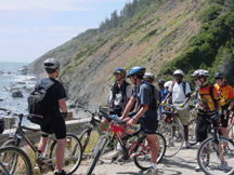 Hill, which had a summit of
690-feet and we didn't know that this would be one of our more difficult
climbs. Many of us were questioning our decision to go on this ride
while climbing the hill that woudn't end. At the top, we stopped at
the first of many fantastic views of the Pacific (see photo.) We cycled through Westport and
across the Ten Mile River Bridge. We cycled 22 miles and arrived at
our first campsite, MacKerricher Beach State
Park.
Hill, which had a summit of
690-feet and we didn't know that this would be one of our more difficult
climbs. Many of us were questioning our decision to go on this ride
while climbing the hill that woudn't end. At the top, we stopped at
the first of many fantastic views of the Pacific (see photo.) We cycled through Westport and
across the Ten Mile River Bridge. We cycled 22 miles and arrived at
our first campsite, MacKerricher Beach State
Park.
MacKerricher had two small lakes, tide pools, fishing and other things (map), but we were too tired after an early start, a long car and our first taste of biking up hills to see much of anything. We set up the camp, ate dinner, played a game and got a good night's sleep.
Day 2: MacKerricher Beach State Park to Manchester Beach KOA
The guidebooks describes the ride as 'very scenic, but
strenuous.' It also said the ride was short, only 42 miles! A 3-mile ride
from our campsite took us into Fort Bragg. One of our scouts had a flat
tire that required a special tool, which took us some time to track down
and get his bike fixed. While the main pack waited in Fort Bragg, we saw
people waiting f or
the famed Skunk Train that goes between Fort Bragg and Willits.
or
the famed Skunk Train that goes between Fort Bragg and Willits.
Once we got going again, we passed by Mendocino and went through Albion. We continued on past the junction of Highway 1 and Highway 128, hoping that no one took the wrong turn. We crossed the Navarro River for a long 1-mile ascent. The sign that said, "Narrow Winding Road For The Next 21 Miles," was not very encouraging.
We then passed through the town of Elk and reached the Manchester Beach turnoff. We reserved a group site at Manchester KOA instead of Manchester State Park. Manchester Beach KOA is nearer to Highway 1, but the real reason was the amenities. After settling in, we headed over to the swimming pool and the hot tub (which only adults could use.) Manchester KOA also had free hot showers! After dinner, the scouts had enough energy from some capture the flag.
Day 3 Manchester to Gerstle Cove Campgrounds at
Salt Point State Park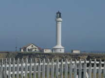
We cycled south through Manchester. The road continued to be steep and narrow. At mile 4.9, most of the scouts made a side-trip to Point Arena lighthouse. Mr. Snyder took the special tour and was told that the rotating mechanism floated on a pool of mercury, which was being removed. After the renovation, the lighthouse would no longer be available for tour. FACTOID. Point Arena is the closest point on the continental US to the Hawaiian Islands.
At mile 20.9, we left Mendocino County and entered
Sonoma County at the Gualala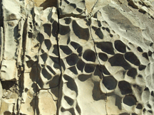 River bridge. We stopped for lunch at Gualala Point Regional
Park. Once
on the road, we biked through the Sea Ranch area. At 34.7 miles, we
entered the boundary of Salt Point State
Park. At 38.9 miles, we reached
Gerstle Cove Campground (map). There was a short ride up the hill to the group
site. Salt Point State Park was full of different geological and tide
pool areas to explore. The area also had some fossilized clams, worms
and crabs. Nearby, there was a pygmy forest, a grove of trees that
remained dwarfed due to poor soil and rough climate. We had a
campfire that evening and worked on some trail to first class skills.
The group site had a large barbeque pit and we used it to full
advantage. No showers at Gerstle, but the area was full of interesting
things to see. If you like geology, then check out the link to learn
more about Gerstle's Geology: http://www.geologyfieldtrips.com/saltpointlake.htm
River bridge. We stopped for lunch at Gualala Point Regional
Park. Once
on the road, we biked through the Sea Ranch area. At 34.7 miles, we
entered the boundary of Salt Point State
Park. At 38.9 miles, we reached
Gerstle Cove Campground (map). There was a short ride up the hill to the group
site. Salt Point State Park was full of different geological and tide
pool areas to explore. The area also had some fossilized clams, worms
and crabs. Nearby, there was a pygmy forest, a grove of trees that
remained dwarfed due to poor soil and rough climate. We had a
campfire that evening and worked on some trail to first class skills.
The group site had a large barbeque pit and we used it to full
advantage. No showers at Gerstle, but the area was full of interesting
things to see. If you like geology, then check out the link to learn
more about Gerstle's Geology: http://www.geologyfieldtrips.com/saltpointlake.htm
Day 4 Salt Point State Park to Bodega Dunes State Beach
From Gerstle Cove, we continued our trek south on Highway 1. At 6.5 miles, we arrived at Fort Ross State Historical Park.
While at the fort, some of the boys took turns
ringing the bell and viewing the cannons the Russians had placed there. Fort Ross was established in 1812 by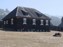 Russians as an outpost for sea otter hunters and a permanent trade base.
It was the southernmost outpost of a Russian presence in the Pacific
Northwest. Ross was derived from Russia. We learned that they had
actually conscripted the local Indians to hunt fur for them.
Russians as an outpost for sea otter hunters and a permanent trade base.
It was the southernmost outpost of a Russian presence in the Pacific
Northwest. Ross was derived from Russia. We learned that they had
actually conscripted the local Indians to hunt fur for them.
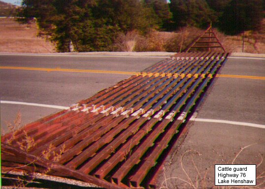
After viewing the fort and museum, we continued our lengthy break to perform last minute safety checks. The guidebook gave us forewarning that there would be a long ascent to the top of a hill that then rapidly descends to almost sea level. This was the steepest segment of the Pacific Coast Highway, even steeper than some of the parts in Big Sur. We also had last minute discussions on how to safely traverse the seven cattle guards that we would encounter on this day's ride. Cattle guards are a series of metal grates laid horizontally on the ground to prevent cows from leaving the area. The only way to ride over them is absolutely straight.
We finally began the ascent and formed into three groups. We all passed through the cow guards without mishap. Finally after reaching the top, the road had a series of switchbacks. We received a call that one of our scouts was down. It was a surprise that it was one of our better riders and we found out later that he had fishtailed on one of the switchbacks trying to slow down and lost control. After some heads-up actions by a couple of our scouts, he was taken to a hospital in Santa Rosa . We stopped at Russian Gulch to do a headcount and get some water before resuming our ride. We decided to call this area "Stephen-Was-Russian- Too-Fast Gulch" but it's listed on the map as "Russian Gulch."
We had another climb and cycled through Jenner. At mile 18.4, we crossed the Russian River. We passed a lot of small beaches on this leg of the ride: Goat Rock SB, Shell Beach, Wright's Beach, Duncan's Landing Beach, Portuguese Beach, Schoolhouse Beach and North Salmon Beach. We finally reached Bodega Dunes State Beach. Bodega Dunes had hot showers and ironically, a short riding day turned out to be a day that stretched into a long one. We found out later that Stephen was doing fine. We had a couple of scouts that were under the weather and they got a ride home after dinner. Bodega Dunes didn't have a group site, but we got several sites near each other. Bring ear plugs or the foghorn may keep you up if it's foggy.
Day 5 Bodega Dunes State Beach to Samuel P. Taylor State Park
From Bodega Dunes, we continued south on Highway 1. At mile 11.5, we left Sonoma County and entered Marin County. We cycled through the town of Tomales and then we rode parallel to Tomales Bay. The views were spectacular as we saw small cays and lots of wildlife in the bay. We finally stopped at Marshall where the lead group found a great clam chowder cafe right on the bay.
As we neared Pt. Reyes, we began heading inland. We cycled through Olema and then turned on Sir Francis Drake Blvd. The intersection is a very busy 4-way stop so make sure that the scouts practice good safety here.
From Olema, there were two long climbs up to Samuel P. Taylor SP. There was a paved cycling trail that takes you right into Samuel P. Taylor, but most missed it and stayed on Sir Francis Drake. Today's ride covered 40.6 miles with the hills at the end so it was one of the more difficult days. FYI, Olema is just outside of Pt Reyes National Seashore.
There are two group camps at Samuel P. Taylor. There was a nice cooking area and hot showers nearby. One of the scouts had to leave to join his choir group for a concert so we were now down to 15 scouts. The cooking area had sinks so clean-up was a lot easier.
Day 6 Samuel P. Taylor to Rob Hill Campground at the Presidio
From Samuel P. Taylor, we continued east on Sir Francis Drake Blvd. The first few miles were difficult as this section of the road was in need of repair. No shoulders and full of pot holes. Fortunately, this was downhill and so we were able to get past this area in short time. We cycled through the rolling hills and took a short break at Fairfax.
We continued our ride through side streets of this area (stay off of Sir Francis Drake, it's too busy) and then made our way to bicycle trails through Marin. Marin is putting in cycling paths and we found one of these that took us in and around the area, but one area hadn't been completed that would have avoided a sharp hill in a busy area. It's well worth purchasing a Marin County Bicycle Map so that you can see their recommended routes through Marin over to Sausalito.
Around mile 20, we were in Sausalito and stopped at the SF Bay Model exhibit while the more die-harded visited a great cycling shop. The SF Bay Model is a large working model of the San Francisco Bay and its waterways. The model is over 1.5 acres in size!! The model was built by the Army Corp of Engineers to study how to maintain the waterways and levee systems around the bay. There is no fee and it's a great place to have water and food before we tackle cycling through the busy streets of Sausalito.
From Sausalito, we drove through the middle of town
and then up a short but steep h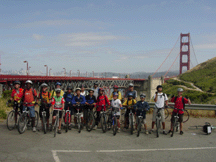 ill on Alexander Avenue.
There is an alternate path, but it's just as steep and more round-about
than attacking the hill. We then took
another head count on the north side of the Golden Gate. We cycled
across the bridge and then reformed near the visitor's center at the
bridge before heading over to our campsite
off of Lincoln Blvd. We made use of the restrooms and snack bar.
From the Golden Gate, you're at the Presidio,
the old Army complex. At mile 29, we reached the Rob Hill campgroundsLincoln is very busy during rush hour and you have to make a left turn
up the hill past the World War II monument to get to the campsite. We
relaxed, picked and ate blackberries, played games and had a great steak dinner. We
had a campfire before we bedded down for our final leg home.
ill on Alexander Avenue.
There is an alternate path, but it's just as steep and more round-about
than attacking the hill. We then took
another head count on the north side of the Golden Gate. We cycled
across the bridge and then reformed near the visitor's center at the
bridge before heading over to our campsite
off of Lincoln Blvd. We made use of the restrooms and snack bar.
From the Golden Gate, you're at the Presidio,
the old Army complex. At mile 29, we reached the Rob Hill campgroundsLincoln is very busy during rush hour and you have to make a left turn
up the hill past the World War II monument to get to the campsite. We
relaxed, picked and ate blackberries, played games and had a great steak dinner. We
had a campfire before we bedded down for our final leg home.
For those with energy, you can take the Presidio Historic Trail that takes you around the various sites and earn your patch through the San Francisco Bay Area Council.
Day 7 Rob Hill Campground to Kennedy Middle School
We
had an early start on this day since we had a 54.5-mile ride ahead of
us. After a carbo-loaded breakfast and making sandwiches, we went back
to Lincoln and headed downhill until we reac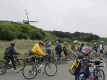 hed 28th
Ave. and turned south on 28th. We then took Cabrillo towards the ocean.
At the Great Highway, we headed south passing the windmill at the Golden Gate Park. We continued south
on the Great Highway and then cut over to Daly City. The Peninsula Bicycle & Pedestrian Coalition
has a peninsula
route that takes you down from SF to points south.
hed 28th
Ave. and turned south on 28th. We then took Cabrillo towards the ocean.
At the Great Highway, we headed south passing the windmill at the Golden Gate Park. We continued south
on the Great Highway and then cut over to Daly City. The Peninsula Bicycle & Pedestrian Coalition
has a peninsula
route that takes you down from SF to points south.
We cycled up a couple of large hills (the last of really tough hills) as we cycled through residential areas of Daly City. We kept hearing the old commercial in our head, "Top of the Hill in Daly City." From there, we cycled over to Sawyer Camp Trail. To get there, you have to do a jog around 280 and then back to the other side of 280 to reach the trailhead.
Sawyer Camp Trail is one of the most popular trails in the entire bay area. It is paved and runs through past Crystal Spring Reservoirs providing all kinds of sights. Since it was Saturday, the trail was heavily used by people hiking, jogging, roller-blading and biking. Heading south was easy as this is mostly downhill.
We stopped for lunch, water and restroom break at the south end of the trail before resuming our ride home. A short climb up Ralston and then over to Cañada Road. Once again, the terrain was 'rolling.' We cycled past Pulgas Water Temple, an interesting site that was built with the completion of Crystal Springs. It's only open on weekdays so the gates were closed. We took a short break here and a van pulled up. It turned out to be Stephen, who stopped to see us before heading home. That was great surprise. We continued to head down the peninsula and the scenery changed from country to one dotted with homes as we headed into Woodside.
We stopped at
Robert's grocery in Woodside for a break.
The most popular item was ice cream. From t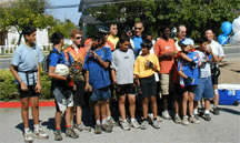 here, we headed through winding roads
in Woodside and then the Palo Alto Hills past the Alpine Beer Gardens
aka Rossotti's aka Zott's. From there, it was on to Arastadero Road to
Foothill Blvd. Foothill Blvd. was a familiar sight as we had biked along
this road for several of our training runs. Once we hit Foothill and
Grant Road, we knew we were very close. There were several routes to
Kennedy and our group took one that we used on several of our training
runs. We headed up Foothill and over to Linda Vista and back to Kennedy.
When we finally arrived, we were
surprised to see a large welcoming party made up of family and friends.
They had all kinds of refreshments and snacks. What a great way to end a great experience.
here, we headed through winding roads
in Woodside and then the Palo Alto Hills past the Alpine Beer Gardens
aka Rossotti's aka Zott's. From there, it was on to Arastadero Road to
Foothill Blvd. Foothill Blvd. was a familiar sight as we had biked along
this road for several of our training runs. Once we hit Foothill and
Grant Road, we knew we were very close. There were several routes to
Kennedy and our group took one that we used on several of our training
runs. We headed up Foothill and over to Linda Vista and back to Kennedy.
When we finally arrived, we were
surprised to see a large welcoming party made up of family and friends.
They had all kinds of refreshments and snacks. What a great way to end a great experience.
The final statistics were 265-miles of riding (270-miles for those that also made the side trip to Point Arena) and over 15,000 vertical feet of climbing.
|
Day |
Route |
Miles |
Climb
(Feet) |
|
1 |
Louisiana
Pacific Pacific Picnic area to MacKerricher SP |
24.0 |
2,010 |
|
2 |
MacKerricher
SP to Manchester Beach KOA |
42.7 |
2,470 |
|
3 |
Manchester
to Salt Point SP (Gerstner) *5 miles to lighthouse |
30.4* |
2,070 |
|
4 |
Salt
Point to Bodega Dunes SP |
46.6 |
3,050 |
|
5 |
Bodega
Dunes SP to Samuel P. Taylor SP |
42.0 |
1,040 |
|
6 |
Samuel
Taylor SP to SF Presidio (Rob Hill) |
33.6 |
1,700 |
|
7 |
Presidio
to Kennedy, Cupertino |
54.5 |
2,760 |
|
|
Totals |
270.0 |
15,000 |
Updated January 23, 2016