Cycling
Coyote Creek Trail
SCOUT OUTINGS
Aviation
Space
Automobiles
Ships & Naval
Trains
Canoeing
Kayaking
Rafting
Sailing
Windsurfing
State
National
County
Regional
Indoor
Rock
Historic
Local
Rim of the Bay
Skyline
Bay Area Ridge
Tahoe Rim
Pacific Crest
Scuba
Stand Up Paddling
Surfing
Swimming
![]() Troop
494 Past or planned outing
Troop
494 Past or planned outing
Coyote Creek Trail
What: Cycling
Where: From Hellyer Park South
Note: For 2004, the Coyote Classic sponsored by the SCCC will start at the model airplane park
Link to map: http://www.parkhere.org/scc/assets/docs/159784coyote_trail.pdf
Link to Coyote Creek Classic Map: http://www.sccc-scouting.org/sccc/files/lfl/03_cccc_map.pdf This is the 2003 course and map.
Summary: The Coyote Creek Trail is a long, paved, mostly level multi-use trail that runs along Coyote Creek from South San Jose, through the Coyote Valley, and ends near Anderson Lake in Morgan Hill. A large part of it is through rural areas, but it is a well-developed trail.
Leaving Hellyer Park, the trail goes beneath Hwy 101 and then runs parallel to it. At Silicon Valley Blvd., the trail passes behind the Holiday Inn and you can park nearby, avoiding paying fees to park at Hellyer.
South of Bernal Road,
the Coyote Creek Trail ducks under Hwy 101, passes by some new
subdivisions. It runs along Metcalf Park, which has restrooms, picnic
tables and drinking fountains. The trail continues alongside a series of
percolation ponds, including one used for water-skiing, then crosses
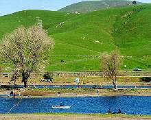
Coyote Creek passing by Parkway Lakes.
|
|
|
|
Parkway Lakes, San Jose |
Coyote Ranch, Coyote Valley |
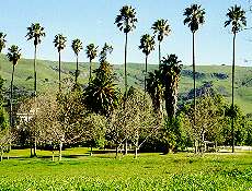
The trail
passes by horse ranches, a nursery with alert watch dogs,
open fields, fruit orchards, and a golf course. There is currently some
construction in this area as they are building a new overpass, but not
on weekends.
South of the golf course, the trail runs through more open fields. Past Ogier
Avenue, it passes by an R/C airplane field run by a model airplane club.
There is a drinking fountain and portable toilets for those needing to
take care of either matter.
The trail follows along a wide portion of the creek. In season, the cottonwood trees are a nuisance as you try to avoid inhaling large cotton balls floating in the wind. As you head south, there is another rest area in an undeveloped park. Water and portable toilets are available. You can continue to Anderson Lake or turn at this point.